Download GPS files for Seven Teacups:
• GPS track & waypoints
Photo album:
• Seven Teacups
Seven Teacups Canyon
 Facts:
Car approach: 20 miles
Hike in: 2.6 miles
Elevation gain: 550 ft.
Canyon length: 0.5 miles
Total canyon descent: 300 ft.
Hike out: 2.1 miles
Elevation loss: 200 ft.
Duration: 7:50 h.
Date: 09/02/2012Gear: 2 x 50m ropes, wetsuit: 4 mm or more.
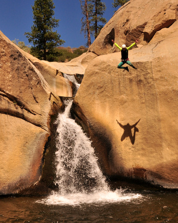
The Seven Teacups is a fun and short canyon worth exploring and can be combined with other activities on the Kernville area. The water erosion has formed seven circular pools one after the other linked by beautiful waterfalls. The temperature of the water is lower than the one in the Kern and even in the middle of the summer, long and thicker than 3mm wet suits are necessary. The canyon involves several swims for a few yards. The canyon is quite open and there are multiple spots in the sun to warm up and rest for a snack.
Car Approach
From Kernville, take the County Rd 521 (a.k.a. Kern River Highway or Mountain Road 99) North. Drive for about 20 miles, pass the Sherman Pass road and cross the Kern River bridge. Park at the parking space right after the bridge. There are restrooms here.
Hike in

From the parking lot cross the pedestrian bridge and go down the stairs. Start hiking upstream. The trail follows the Kern River. This is a pleasant hike, especially if done early enough to be in the shade before the sun is too vertical. There is some poison oak along the way but the trail is wide enough to avoid it if you pay attention. After 2.1 miles you get to the Seven Teacups canyon exit, on the opposite bank. Keep walking upstream on the Kern for 0.1 mile looking for a good crossing spot. We used a rope to help the crossing but the water was just 3 feet deep.
Once on the other bank, hike upstream for a few yards and look for a steep trail going up the hill. The trail to the top of this hill is about 0.2 miles and will be exposed to the full sun. Once at the top, bear right and hike without losing too much elevation. After 130 yards look for a drainage and follow it to the left, towards the canyon. 100 yards later you will find the creek you’ll descent.
Canyon
Gear up and start the descent. Soon you will arrive at the first jump (12 ft.). There are a couple of options here, jump from the rock in the middle of the stream or from the left side wall. The first rappel is rigged from a natural arch between the first and second teacups. Both pools can be bypassed on the right. You can also swim under the arch connecting both pools. You can drop to the third teacup without a rope but to get to the fourth teacup you need to go through 2 rappels. The catch is that the anchor for the first of these 2 rappels is at the natural arch previously mentioned so be careful not to miss it. The second rappel is the most challenging section of the canyon and can be dangerous with high flow. This rappel goes through the spout and lands into the fourth teacup pool between the waterfall and the wall. The walls of the waterfall are slippery and the funnel the rock creates multiplies the force of the water pouring down.
To the right of the fourth teacup there is a nice wide and sunny ledge to warm up. The easiest way to access the ledge is to swim towards the drainage of the pool and climb to the ledge. It may be necessary to first throw your pack and then climb yourself since the walls are slippery. After one person has climbed, he/she can help the rest of the group to climb to that ledge without having to get close to the drainage. For the extra adventurous, the wall across from the pool can be climbed for a spectacular jump. Cross the stream at the drainage and climb the wall towards the waterfall. The jump requires a short run on a steep wall, so make sure you calculate your steps right.
The following teacups can be either jumped or downclimbed with no problems. The next challenge is the tallest waterfall in the canyon (60 ft.). The anchor is in a tree on the left side. The rappel goes down through a narrow chute leaving the waterfall to your left. Once at the bottom, go over the boulders and swim downstream through a narrow passage.
After a few more pools that can be jumped of downclimbed, you will arrive to the final drop, which is a two stage rappel. There are two options here. The first one has the anchor on a tree about 12 ft up the right wall, on a somewhat exposed location. This rappel ends on a broader ledge where a second anchor is installed. The second option for this first stage of the last drop is the anchor on the left wall. From there, drop to a pool and keep rappelling down to a second one. Cross the creek there and look for the anchor on the right wall.
The second (and common) stage for this last rappel has a second pitch halfway down to guide the rappel away from the waterfall. The intermediate pitch is conveniently located on a rock hole where you can stand comfortably. The end of that second rappel is in a slot with deep water. You will have to swim away from the waterfall and avoid the backflow.
After this last rappel the last fun feature of the Seven Teacups is the toboggan pouring into the Kern River. Watch out for the very last part of it since it ends in a rock. It can be avoided aiming to the right.
Hike out
From here, look for a good crossing to go back to the trail. For strong swimmers and depending on the Kern current, going across right at the exit is a plausible option. Otherwise, hike upstream and/or use a rope to assist the group. Once on the East bank, take off all your gear and hike back to the car. Remember the poison oak!


