Download GPS files for Copper Ridge Loop:
• GPS track & waypoints
Photo album:
• Copper Ridge Loop
North Cascades NP:
• North Cascades NP
• Trip planner
Copper Ridge loop
This adventure is a tough 3 day hike in the Northern section of North Cascades National Park.
Day 1: From the Hannegan trail head to Egg Lake camp
Day 2: From Egg Lake camp to Indian Creek camp
Day 3: From Indian Creek camp to the trailhead
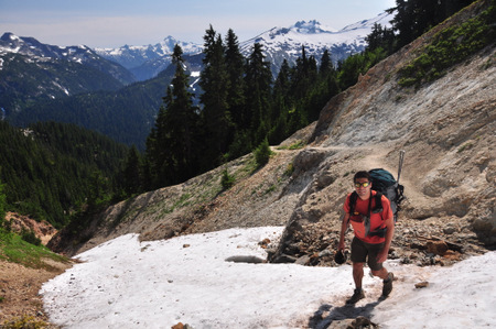
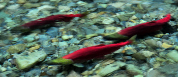
The hike described in this web page is about 33.6 miles and more than 8.000 ft. elevation gain. We did it in 3 strenuous days but it may be more enjoyable in 4 days. It visits the North section of the North Cascades National Park, only a few miles from the Canadian border. The closest town is Glacier on Road 542. The itinerary starts at the Hannegan Pass trailhead and climbs to the pass of the same name. From here, the route loops for about 25 miles to get to this same spot and goes back down to the trailhead. The first half of the loop climbs to the Copper Ridge offering spectacular views of the craggy peaks of Mount Redoubt and Bear Mountain as well as Mount Shuksan, the Nooksack Tower and its cracked glacier. Once up on the ridge, you are mostly outside the dense forests and surrounded by grassy fields with lots of wild flowers and the expanse views can be enjoyed for miles. At the end of the ridge, a steep drop will take you down to the Chilliwack valley. The crossing of the Chilliwack was one of the highlights of our trip since the sockeye salmons were running and we could see dozens of them swimming upstream. The return to the Hannegan pass is along the Chilliwack valley giving you a totally different atmosphere compared to the Copper Ridge. Here you’ll be walking in the dense and humid forest where the sun hardly gets to the ground. Ferns, berries and all sort of mushrooms cover this rich ecosystem. The cable car crossing the Chilliwack River for the second time adds some adventure to the hike. Part of this section belongs to the Pacific Northwest Trail. The Pacific Northwest Trail stretches from Glacier National Park in Montana to Cape Alava on the Pacific Ocean in Olympic National Park.
The closest ranger station to the Hannegan trailhead is in Glacier, a short distance passed the town. If you get there while they are closed, there is a self-issuing permit station at the door. The rangers will post there a list of the campgrounds available and you can write your own permit. In the ranger station plaza, where all the dioramas are, you can pay for the car pass. So if you get there late the night before your hike starts, you can do all the paperwork right there and avoid waiting for them to open in the morning.

There are at least 2 campgrounds in the area. The Douglas Fir campground is 1.5 miles East the ranger station and the Silver Fir campground is 13 miles East, both following the Road 542. The later one is more convenient since it’s closer to the trailhead and you’ll sleep at some higher altitude, starting your acclimatization earlier. The campground is on the right hand side of the road shortly after crossing the river. Both campgrounds reserve 10 sites for First Come First Serve, but if you get there late, the chances to find an empty site will be low during the peak season weekends. On the day we started the hike, we found many tents on the sides of fire road FS32. Even there were tents at the parking lot at the end of the road. Not sure if that permitted though.
From the Silver Fir campground, take Road 542 towards Glacier and right after crossing the river, take the dirt road on the right. This is Fire road FS32. After aprox. 1.5 miles take the left fork. This is Fire road FS32 and it will take you to the trailhead. It’s a total of 5.3 miles on dirt road. At the parking lot there is a trash container and a restroom.
Day 1: From the Hannegan trail head to Egg Lake camp
Facts: 
Distance: 8.3 miles
Elevation gain: 3250 ft.
Total descent: 1250 ft.
Duration: 6:40 h.
Date: 08/18/2012
Description of the route:
The trail starts at the end of the parking lot, just behind the sign. The path goes parallel to the river but the forest is so dense that you cannot see it. The trail goes uphill from the beginning, but the first mile is very gentle. After that it gets a little steeper. However, it’s the last mile to the Hannegan pass the one will make you sweat. On the way up there are at least a couple of streams where you can get water from.This first section to the pass runs on the north side of the valley of the Ruth River. The north faces of the range across are still covered by large patches of snow and multiple waterfalls rush down the steep slopes to join the river on the valley. The tall firs along the path have moss hanging from their braches and the ground is totally covered by vegetation. The trail is mostly compacted dirt but dusty during some stretches. At mile 3.6, the right fork takes to a campground, still outside of the National Park. Take the left branch and keep climbing.
At the Hannegan pass (mile 4 and 5000 ft), there are several trails that split. To your left, still among the tress, the one that climbs to Hannegan Peak. The one that goes to the Boundary campground goes on a NE direction and tt’s the clearest one. Another one goes straight down to an unofficial campground, called Dead Mans Camp on some maps. To the right a fourth trail goes up towards Ruth Mountain following some switchbacks.
The trail to the Boundary campground starts flat but rapidly goes down through some steep zigzags for half mile where it crosses a stream, still covered by snow when we did it. From here to the Egg Lake campground we had to cross several snow patches but the snow was soft enough and not on steep slopes to need and special hardware like crampons or ice axes. At mile 4.8 from the trailhead is the National Park boundary. This is where the Boundary campground is. The bear box is visible from the trail. Here the trail forks. The left branch takes you to the Copper Ridge; the right one to the Chilliwack trail. Take the left one to follow our itinerary.
From here there are 2 miles of steady climb, much like the last mile to the pass. At the end of this climb (mile 6.7 from the beginning and 5500 ft. of elevation) there is an excellent 360 degrees view of the park. You can see craggy peaks with sharp crests, cracked glaciers and deep valleys totally covered by dense forests.
Now the trail goes down and back up through a couple of switchbacks. At mile 7.6 you get to a sign. The trail to the right goes to the Silesia campground, a few yards away and with excellent views from the top of the hill. The left fork continues on the Copper Ridge trail. At mile 7.8 is the junction for the Egg Lake campground. You can see the lake from here, down to your left. To your right a less marked trail goes to a nice viewpoint from where you can see the valley you will be hiking on the next 2 days. Also from here you can see the zigzags up to the lookout tower.
It’s only 0.3 miles from the junction to the Egg Lake. There are only 3 campsites. The first one is right after the bear box. The second one is on that same crest a little farther on (there is a small trail that snakes up from the drainage of the lake. The third one and farthest away but with magnificent views is across the lake. Look for the trail going up after crossing the lake drainage. All three campsites are great and give you the feeling of being alone. There was still ice and snow around the lake when we did this hike and the water was freezing.
Profile from Hannegan trailhead to Egg Lake.
Day 2: From Egg Lake camp to Indian Creek camp
Facts:
Distance: 10.9 miles
Elevation gain: 1900 ft.
Total descent: 4700 ft.
Duration: 9:00 h.
Date: 08/19/2012
Description of the route:
The climb back to the main trail is a good warm up for this long day. It’s another beautiful day and the scenery is incredible: awesome views, wild flowers, greenery everywhere… Before the final climb to the lookout tower we saw a bear grazing for berries. Initially we thought it was a grizzly because of the rounded ears but the ranger at the lookout tower said grizzlies have not been spotted in the park for many years. So it was probably a black bear despite the blonde fur.

The lookout tower (2.2 miles and 6.230 ft.) is the highest point of the itinerary and the views from there are just fantastic. Here we also saw a family of grouses foraging around and short after a family of ptarmigans with 3 chicks. Strangely enough the ptarmigans let us approach them really close, like 2 feet away!
After some downhill switchbacks, at mile 3.5, is the junction to the Copper Lake campground. The views of the deep blue and green water of the lake from the switchbacks are spectacular. At mile 4, you will find a rushing creek where you can get water. Hiking poles are useful here to cross it. After the lookout tower, the trail goes up and down a few times. Actually, today’s elevation gain is 1900 ft. However, at about mile 6, the trail drops 3400 ft. in 4 miles. The last half mile before the Chilliwack crossing is not so well marked so pay attention to cairns and cut logs. Especially tricky is the section between waypoints 0206 and 0208, since the trails follows a creek bed for a short stretch and several small logs block the path.
At mile 9.8 you should be ready to cross the Chilliwack River (look for pink bands attached to a tree branch on each side of the river). When we were there, the water was 2 feet deep. Sockeye salmons were abundant, swimming upstream and then letting the current drag them back down. It’s amazing the dark olive green color of their heads and the intense red of their bodies. Only 0.1 miles later you’ll ford the Indian Creek, a little bit wider and same depth. We found here even more salmons but in less good shape. Most of them had the bright red skin faded on their backs and even some were dead on the shore. It an incredible experience see them fleeing from you as you ford the river. Watch out for bears here. We found the border patrol and they saw a couple of them fishing near the Bear Creek campground (closer to the border with Canada).
At mile 10.2 turn right towards Indian Creek campground. The section of the trail from the river to the campground and on is overgrown in some stretches and you can’t see much. At mile 10.8 is the junction to the campground. It has 3 campsites also very secluded.
Profile from Egg Lake camp to Indian Creek camp.
Day 3: From Indian Creek camp to the trailhead
Facts:
Distance: 14.4 miles
Elevation gain: 3000 ft.
Total descent: 2200 ft.
Duration: 9:00 h.
Date: 08/20/2012
Description of the route:
We start early in the morning for a long and tough day, not only because of the distance but also for the elevation gain. The trail through the valley runs in the shade of a dense forest with its floor covered with bright green vegetation and all sorts of mushrooms, moss and ferns. At mile 2.7 you’ll get to the fork towards the Whatcom Pass and the Ross Lake. Go right towards the US Cabin campground. At mile 3.5 you have a choice for how to cross again the Chilliwack River. If you go right and down, you’ll have to ford it. Left and up for the cable car, which was our choice. The cable car tower is at mile 3.7. It was funny to pull ourselves on this suspended cart across the river. A short distance after the arriving cable car tower, the trail coming from the ford joins on the right hand side.
At mile 4.5 is the junction for the US Cabin campground and at mile 7.0 is the junction for the Copper Creek campground, just before crossing that creek. There is another access to the same campground on the other bank. Here is where the steep climb of the day begins. In about 3 miles you’ll ascend 2000 ft. The hiking poles proved to be very helpful again. At mile 8.3 you will cross a stream where you can refill water.
You’ll reach Boundary camp at mile 9.4. Go left here towards the Hannegan pass (mile 10.3). Approximately 0.4 miles down the pass, there is a stream to replenish water. From the pass, it’s all the way down to the trailhead and the end of this adventure.
Profile from Indian Creek camp to Hannegan Pass trailhead,


